Earth Observation (EO) is transforming the way we monitor infrastructure and assets by providing a unique vantage point from space. Among its many benefits, EO allows us to track changes over time, offering a dynamic view of our world that goes far beyond simple images. Modern satellites can capture a wealth of data, from soil moisture levels to vegetation health, delivering insights that were once impossible to obtain.
Davra is at the forefront of integrating Earth Observation with the Internet of Things (IoT). This powerful combination brings together the best of both worlds, creating a comprehensive remote monitoring solution that is transforming industries such as mining, oil and gas, construction, and infrastructure management. By merging ground-based IoT sensors with satellite imagery, organisations can achieve a more holistic understanding of their environments.
In this article, we'll explore the integration of Earth Observation with IoT, explain how it works, and highlight how the combination works together to deliver greater value.
What is Earth Observation
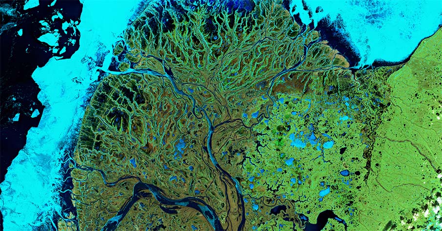
Earth Observation, otherwise known as Remote Sensing can be defined as the use of any airborne or space-based sensor to collect data. Usually, this is in the form of an image that looks at some area of the Electromagnetic (EM) Spectrum.
Still a relatively new offering, EO is establishing itself thanks to an explosion in commercial satellites and companies harnessing the data, plus support from space agencies such as ESA and NASA. As such, more industries are realising the benefits.
Earth Observation data is updated regularly - typically every time the satellite orbits the Earth. This provides important, actionable data about the present, as well as a vast historical time series that enables trends and patterns to be identified that may otherwise go unnoticed.
Given advances in communication technology, EO data can now integrate with IoT devices on the ground via IoT platforms and applications. At Davra, we integrate satellite data and ground sensor data as part of Sentinel (opens new window), our mine tailings monitoring and management solution. Before we explore how EO is being used in IoT, we will first take a look at how EO works.
How does EO work
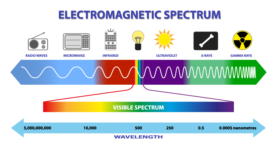
EO sensors work just like a regular camera - light strikes an image sensor, and the output of the sensor is processed within to create an image. The sensor in your camera phone or DSLR captures information in the red, green, and blue channels (RGB) of the visible spectrum. EO sensors, however, are sensitive to a wider range of channels, including infrared and radio waves.
EO sensors split this wider range into multiple channels, known as “bands”. An EO sensor can range from 3 bands (RGB) to 1000s of bands (hyper-spectral). For example, the Sentinel-2 satellite, part of the ESA Copernicus Programme, has 12 bands. When processed correctly, these bands provide valuable information about an area beyond what we can see with our eyes such as estimating soil moisture or vegetation health.
EO data can come from either an airborne or space-based mission. Space-based is much more common due to the support of organisations like ESA and NASA which often release their data as open-source.
What You Need to Know About EO Sensors
There are several important considerations when choosing a satellite for EO purposes, as things can vary from sensor to sensor.
Sensor type - Is the EO sensor active or passive (explained below)? If passive, how many spectral bands can we utilise?
Image resolution - What is the resolution of the images, and how much detail from the images can we make out? Whilst it is “nice” to have incredibly high-resolution imagery 24/7, a spatial resolution of 10-20 metres is usually more than enough to satisfy most requirements. It also reduces the cost to the end user.
Frequency - How often does the satellite constellation revisit the same area? In the case of the Sentinel-1 satellite, it revisits an area every 6 days. However, two images are required to measure displacement, resulting in a 12-day cycle.
Lifespan - Satellite constellation missions have a defined lifespan. Consider how much lifespan is remaining before investing.
Age of the mission - When did the mission start? This is an important consideration when historical data is required, as it will determine the length of the series.
Davra has partnered with the Copernicus Programme (opens new window)–the European Union’s Space Program, for our tailings monitoring solution, Sentinel (more on this later). The programme has a fleet of earth observation satellites monitoring various aspects of the planet, provided free of charge.
Join our Mailing List
Join thousands of professionals and get IoT tips to help you transform your business.

What are Passive EO Sensors
Passive EO sensors rely on the sun's light reflecting off the Earth and being picked up by the sensor. The light detected is either reflected off the atmosphere (if looking at atmospheric gases) or reflected from the ground.
Unfortunately, passive imagery of the ground is hindered by various effects that cannot be mitigated, such as clouds and shadows. In these cases, the best we can do is attempt to remove the affected pixels (known as “masking”). This is more difficult than it would seem and there is a chance that certain cloud or shadow pixels impact the result.
Examples of passive methodologies include algorithms such as the Normalized Difference Vegetation Index (NDVI) which describes the health of the vegetation in the images seen; and the Optical Trapezoid Method (OPTRAM) for detecting soil moisture.
Both methods rely heavily on both the visible and the infrared parts of the EM spectrum and allow for much greater insights into an environment than a standard RGB picture.
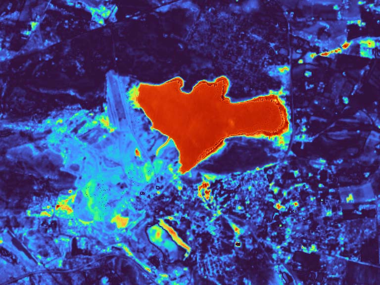 OPTRAM image of a mine tailings facility showing soil moisture levels. Red = higher moisture content. Captured by the Copernicus Sentinel-2 mission, processed by Davra.
What are Active EO Sensors
Active sensors send out a signal and detect when it bounces back from the Earth. Signals tend to be radio waves, such as Synthetic Aperture Radar (SAR), or infrared, such as LiDAR. Active sensors can determine the distance of an object, i.e. its elevation on the ground, by measuring how long it takes the signal to return. They can also detect changes in ground deformation and soil moisture by examining the properties of the returned signals.
Radio waves penetrate cloud cover, meaning data from the ground can be collected no matter the conditions in the atmosphere. Signals can still be interfered with, for example by the ionosphere as well as metallic or flat objects which can cause SAR images to “flare”. Overall, however, the information we get from active sensors is extremely useful.
SAR has many powerful use cases. It allows us to calculate ground deformation with millimetre accuracy, reveal information on soil moisture and biomass, as well as the detection of specific objects on the ground.
InSAR (Interferometric Synthetic Aperture Radar) is a technique for mapping ground deformation by comparing two images of the same area collected at different times. Both InSAR and the passive algorithms discussed in this article will be explained in much more detail in future articles.
Earth Observation in IoT
The combination of EO and IoT is transforming remote monitoring of critical infrastructure. IoT can provide real-time telemetry of practically any metric via remote sensors. In turn, EO offers a perspective and insights unmatched by other techniques. The integration of EO data into IoT applications thus creates a complementary pairing of real-time localised data and wide-area time series data.
This combination of EO and IoT is ideal for any industry or application requiring remote monitoring of critical infrastructure. Examples include smart farming, pipeline monitoring for oil and gas, tailings dam monitoring, and governmental or municipal maintenance of bridges, roads, and dams. We’ll touch on two of these example below.
Remote Monitoring of Mine Tailings
Tailings are the by-products left over from the mining process and are stored in dams or embankments designed to contain the waste. The collapse of these structures causes disastrous consequences for local communities and the environment.
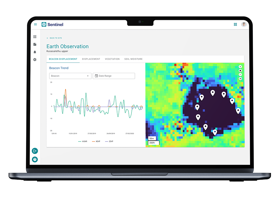
Davra Sentinel is a remote monitoring application for tailings storage facilities (TSF). Sentinel combines EO data with real-time telemetry from ground sensors, providing continuous oversight and improving the safety, efficiency, and compliance of tailings management.
Ground sensors monitor the tailings dam wall. This typically includes piezometers that monitor the pressure or depth of groundwater, and inclinometers and GPS beacons that precisely measure the ground deformation. These sensors are linked to a data logger and transmitted 24/7 to the Sentinel platform.
Sentinel utilises EO data from the Copernicus Programme, including a multi-spectral mission and a SAR mission, providing displacement, soil moisture, and vegetation health data about the entire site.
The EO data enhances the IoT offering in multiple ways:
Eye in the sky - by observing trends that cannot be seen from the ground and providing coverage of areas not critical enough for constant monitoring.
Double confirmation - Confidence - multiple independent measurements give confidence to the user. If soil moisture values from EO show a similar spike to a nearby piezometer, this reinforces a potential issue - such as a leak in the dam wall - and that it must be inspected.
Enhancing models - The combination of IoT and EO creates the opportunity to train and enhance new models, improving the accuracy of measurements in the future.
Long-term view - The time series nature of EO data provides a long-term view of the site. This helps to illustrate important changes in the vicinity, such as the build-up of urban developments, or the return of vegetation once the site is closed.
Smart Farming
Agriculture faces serious challenges in the shape of climate change and an ever-increasing global population requiring farmers to produce more than ever before.
In the face of these challenges, farmers are turning to technology for the answers. Technologies such as EO and IoT will be a key part of the future.
IoT sensors on the ground can monitor soil conditions in real-time including moisture levels, pH, and nutrient levels. Combining this with the capabilities of remote sensing provides enormous additional benefits.
EO algorithms such as NDVI and OPTRAM enable continuous monitoring of crop health and moisture levels over large areas. This helps to identify and address problem areas, even in remote or difficult-to-access locations.
Land can also be segmented, with zonal statistics providing key metrics or alerts based on real-time data. All this enables predictions about the climate informing decisions about when to plant, when to fertilise, or when to harvest.
Once data is uploaded to the IoT platform, it can be accessed anywhere in the world. This fosters the sharing of information and collaboration with international teams to solve problems together.
With these tools in addition to technologies such as AI, drones, and autonomous vehicles, farming is tackling the challenge of producing more, while wasting less.
Summary
The integration of Earth Observation (EO) with IoT data represents a significant advancement in remote monitoring and management across various industries. By leveraging the strengths of both technologies, organizations can achieve unprecedented insights and a more complete understanding of their assets and infrastructure.
EO offers a broad, long-term view from space, capturing data that would be impossible to collect solely from ground-based sensors, while IoT provides real-time, localized data crucial for immediate decision-making.
As the adoption of these technologies grows, the potential for enhanced safety, efficiency, and sustainability in sectors like mining, agriculture, and infrastructure is immense. This powerful combination not only improves operational effectiveness but also positions industries to better respond to the challenges of an ever-changing world.
Look out for future articles that will go into greater detail about the algorithms and technologies we are using at Davra. These will include in-depth discussions on InSAR and spectral indices like NDVI and OPTRAM, as well as a case study on the use of Earth Observation to help prevent or mitigate tailings dam failures.
We welcome your feedback or questions about any of the topics discussed in this or any of our articles. Visit our Contact page to get in touch.
AI and IoT insights to help you transform your business


Copyright © Davra Networks 2026. All rights reserved.
Cookie & Privacy Policy